TRANSFORMING INDIAN AGRICULTURE: MACHINE LEARNING AND SATELLITE IMAGING

Here we explore the role of AI and satellite imagery in revolutionizing Indian agriculture by enhancing precision farming, monitoring crops, optimizing resources, and boosting productivity.

Agriculture Machine Learning and Satellite

Indian Agriculture ecosystem

Agriculture stands as the backbone of rural livelihoods in India, pivotal in advancing food production, credit reforms, and the introduction of marketing strategies. Agriculture still contributes significantly to India’s economy (roughly 15% to India’s GDP). It provides raw materials for industries such as food processing, textiles, and agribusiness. Despite these strides, economic growth is hindered by inefficiencies such as small landholdings, underutilization of farm mechanization, excessive government control, and reliance on governmental support.

Challenges in the Indian Agriculture Ecosystem

1.Fragmented Land Holdings
Majority of farmers in India own fragmented land. An estimate quoted by the the Press Information Bureau stated as of 2023, there were over 12 crore small and marginal farmers in the country, with an average land holding size of less than 1.1 hectares. This limits their ability to adopt modern agriculture practices, as they would not benefit from economies of scale
2.Land degradation
The rapid increase in agricultural productivity in the region has come with a significant toll on land health, marked by extensive erosion, salinity, and deforestation driven by urban expansion and shifting agricultural practices. These challenges put farming at risk and make farmers more vulnerable, underscoring the need for better land management and sustainable farming practices.
3.Soil quality deterioration: 
Excessive use of agrochemicals during the Green Revolution has degraded soil quality, particularly reducing soil organic matter essential for nutrient cycling and structure. Soil acidification from chemical fertilizers has further harmed soil health in tropical regions, affecting over 60% of India’s agricultural land. These challenges threaten future crop yields and highlight the need for sustainable farming practices to preserve soil biodiversity and fertility.
4.Water scarcity and salinization
In many regions of India, agriculture heavily depends on monsoon rains, often leading to water scarcity during dry periods. Insufficient irrigation infrastructure and ineffective water management exacerbate this challenge. Additionally, imprudent water use for irrigation and increased water availability due to climate change have intensified soil salinization through increased waterlogging.
5.Pests, Diseases, and Climate Change:
Farmers face challenges from pests, diseases, and changing climatic patterns Tea Research Association, in its statement, said the revenue loss due to pest infestation in tea plantations is pegged at Rs 2,865 crore per year.  Increase in erratic weather conditions, droughts, floods, and heatwaves impact crop yields and livelihoods. The cyclone in Andhra Pradesh in 2023, is one such incident which flattened thousands of acres of standing crop.
6.Lacking food storages and wastage of food 
According to the Ministry of Food Processing Industries (MFPI), India loses approximately 30% of its agricultural produce every year due to inadequate storage and transportation facilities. Enhancing infrastructure could significantly reduce these losses, ensuring more food availability and less wastage. 
7.Inadequate Agricultural Research and Education, Training and Extension
In 2019, India allocated only 0.7% of its Agricultural GDP to agricultural research, education, extension, and training, significantly below the World Bank’s recommended threshold of 2%. Lack of education and training farmers results in farmers being averse to new sustainable practices.

Role of AI & Satellite imagery in agriculture

Artificial Intelligence (AI) and satellite imagery play pivotal roles in transforming modern agriculture: 1.Precision Farming: AI and satellite imagery enable precision farming techniques by providing real-time data on soil moisture, crop health, and weather patterns. This allows farmers to optimize irrigation, fertilization, and pesticide use, leading to improved crop yields and resource efficiency. AI and ML models can be programmed to provide irrigation advisory for each crop based on historic information, soil information and weather forecast. This can be done with unified platforms that are integrated with multiple information systems such as weather stations, soil sensors, historical data bases and more. 2.Crop Monitoring and Management: Satellite imagery provides detailed insights into crop growth and health across large areas. AI algorithms analyze this data to detect diseases, pests, or nutrient deficiencies early, enabling timely interventions to mitigate risks and optimize yield.

Crop health monitoring module from fieldWISE

Pest forewarning module  in fieldWISE prevented the loss of 6-7 lakh hectares of cotton to pink bollworm and 1.8-2 lakh hectares of maize and jowar to fall armyworm in the 2017-2018 period.

3.Predictive Analytics: AI models can forecast crop yields based on historical data, weather forecasts, and satellite imagery. This helps farmers and policymakers make informed decisions on planting, harvesting, and market planning. In 2018 the sowing advisory feature within fieldWISE contributed to a 10% – 15% boost in groundnut yield in Anantapur district compared to the previous year.

4.Land Use Planning: Satellite imagery aids in monitoring land use changes, soil erosion, and deforestation, supporting sustainable land management practices. AI algorithms analyze this data to optimize land use decisions and preserve natural resources.

5.Weather and Climate Monitoring: Satellites provide continuous monitoring of weather patterns and climate changes. AI models analyze this data to predict weather extremes, such as droughts or floods, allowing farmers to implement adaptive strategies in advance.

fieldWISE’s drought early warning module identified 274 high-risk mandals out of 677. This early detection enabled timely provision of input subsidies, benefiting farmers financially.

6.Market Access and Supply Chain Optimization: AI algorithms analyze satellite data to predict market demand, optimize logistics, and improve supply chain efficiency. This helps farmers access markets more effectively and reduce post-harvest losses.

7.Farm Automation: AI-powered robotics and drones equipped with satellite-guided navigation assist in tasks such as planting, spraying, and harvesting. This reduces labor costs, enhances efficiency, and minimizes environmental impact.

8.Bund Boundary Mapping: In precision agriculture, boundaries are essential as they define the shape and area of fields. These boundaries are critical for monitoring systems and mapping software, ensuring accurate field location and exclusions. With the help of Satellite imagery and AI, field boundaries can be accurately mapped against farmer data. This helps governments, enterprises and financial institutions monitor and validate field details.

Bund boundary mapping of fieldWISE

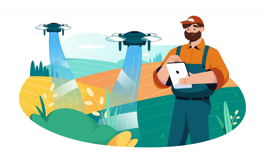
9.Role of GenAI: GenAI-powered chatbots can be developed to provide agricultural advisory to farmers and officers in their native languages. This helps farmers access the latest knowledge and findings related to agricultural practices easily. Farmers can use these chatbots to access weather advisories, irrigation tips, and pest identification alerts, thereby optimizing their agricultural practices.

Supporting Government Initiatives 

The Ministry of Agriculture and Farmers Welfare in India has leveraged Artificial Intelligence (AI) to address various challenges in the agricultural sector and support farmers. Some of the initiatives include:

– ‘Kisan e-Mitra’: An AI-powered chatbot designed to assist farmers with queries related to the PM Kisan Samman Nidhi scheme. This chatbot supports multiple languages and is expanding to cover other government programs.

– National Pest Surveillance System: Utilizes AI and Machine Learning to monitor and mitigate crop losses caused by climate change. This system detects crop issues early, facilitating timely interventions for healthier crops.

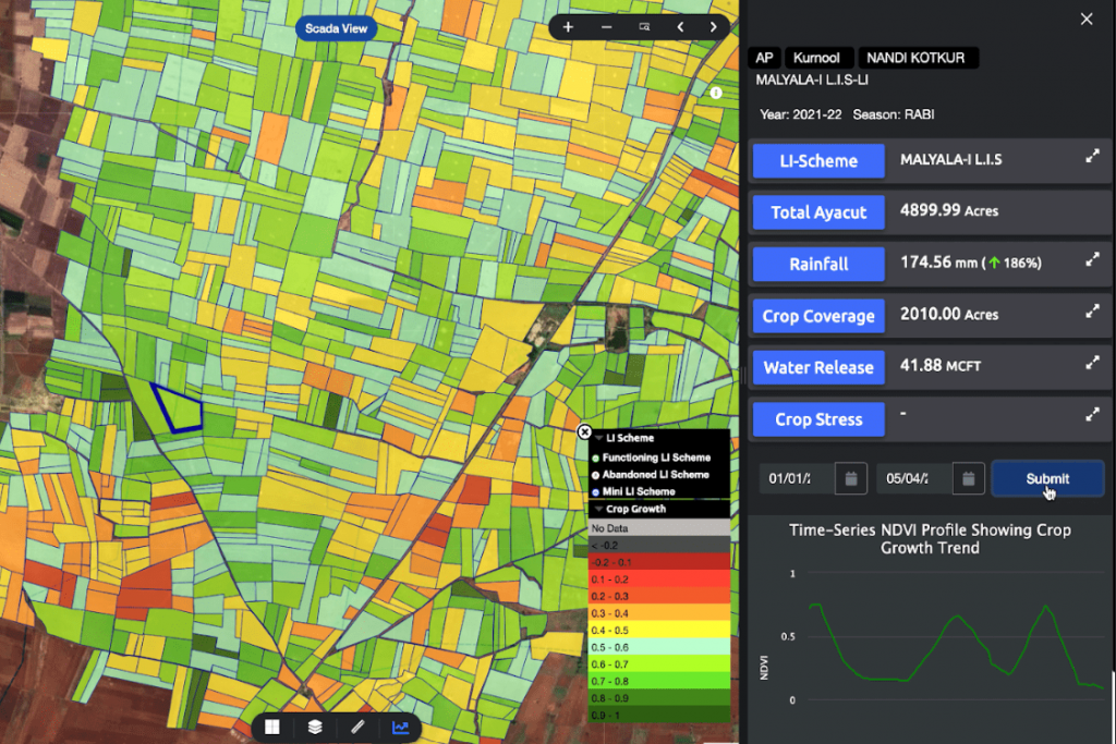
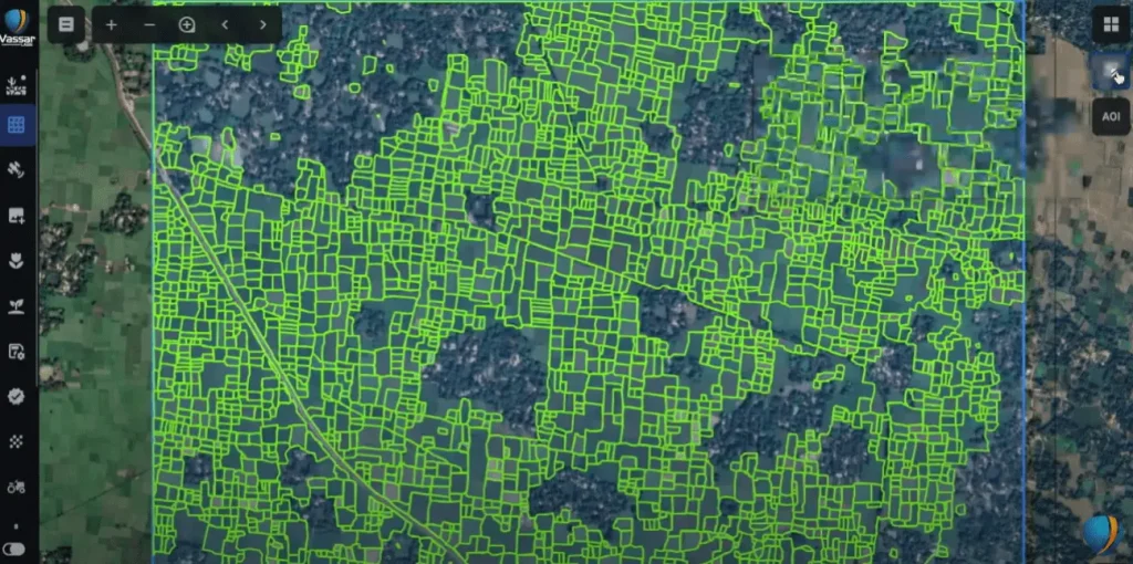
– AI-based analytics: Utilizes field photographs for crop health assessment and integrates satellite, weather, and soil moisture datasets to monitor rice and wheat crops.

These initiatives were announced  by the  Union Minister of Agriculture and Farmers’ in February 2024. The Government has initiated the National e-Governance Plan in Agriculture (NeGP-A), allocating funds to states and union territories for projects leveraging modern technologies such as Artificial Intelligence (AI), Machine Learning (ML), Robotics, Drones, Data Analytics, and Blockchain. These efforts aim to develop innovative solutions following proposals from states, enhancing access to crucial information and digital infrastructure in agriculture. Additionally, the government has announced the development of Digital Public Infrastructure (DPI) for agriculture, promoting open-source and interoperable solutions to empower farmers with comprehensive services like crop planning, health monitoring, access to inputs, credit, insurance, crop estimation, and market intelligence.

Conclusion

AI and satellite imagery revolutionize agriculture by providing valuable insights and optimizing resource management, improving productivity, and fostering sustainable practices. Institutions such as the World Bank and the UN, and governments play a crucial role in supporting farmers to adopt these technologies through funding research, providing subsidies for technology adoption, offering training programs, and establishing policies that promote innovation and technological integration in agriculture. This contribution enhances food security and promotes economic development globally.

Know More About fieldWISE - Indian Agriculture ecosystem

Get In Touch