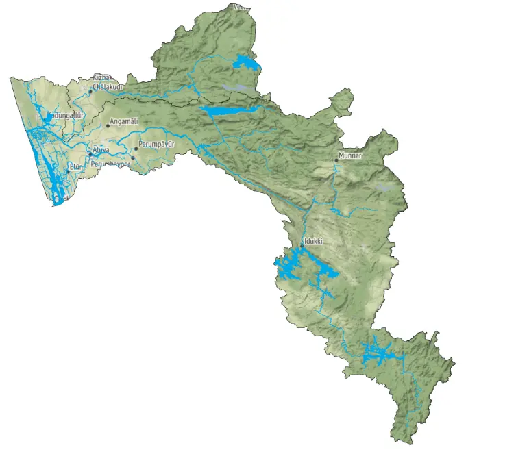
The Periyar-Chalakkudy Basin in Kerala, India, is vital for the region’s water resources and ecology. Originating from the Western Ghats, the Periyar River, stretching 244 kilometres, is Kerala’s longest river. The basin is renowned for its lush greenery and biodiversity but is also prone to periodic devastating floods, notably during the monsoon seasons (June to December). The area experiences a tropical monsoon climate, with heavy rainfall contributing to significant river flow, supported by reservoirs such as Idukki, Idamalayar, and Mullaperiyar dams. The basin covers approximately 5,398 square kilometres, featuring varied topography from high-altitude mountains to coastal plains, characterized by steep slopes that contribute to rapid runoff and flood risks.
Intense monsoonal rains are the primary cause of floods in the Periyar-Chalakkudy Basin. The steep terrain of the Western Ghats facilitates rapid surface runoff, which, combined with saturated soils, exacerbates flood conditions. The operation of dams heavily influences the basin’s hydrology, and sudden releases from reservoirs during heavy rains can also significantly contribute to downstream flooding.

Periyar River Basin (including Chalakkudy River System), Kerala, India.
In August 2018, unprecedented rainfall caused the opening of all five sluice gates of the Idukki Dam for the first time in 26 years, resulting in extensive flooding and damage across the Periyar Basin. This catastrophic event displaced millions of people and caused more than 400 deaths (Mishra et al., 2018) It also resulted in widespread destruction of infrastructure, agriculture, and property.
More about the 2018 flood in Kerala
In August, Kerala experienced heavy rainfall, particularly in hilly districts like Idukki and Wayanad, resulting in severe flooding. Normally receiving around 290 mm of rain during this period, these areas received about 700 mm, triggering floods. Compounding the issue, reservoirs were already filled to high levels by July due to excessive rains. When more rain fell in August, the reservoirs could not handle the excess, leading authorities to open all 34 reservoir shutters without considering downstream impacts, worsening conditions for riverbank communities.
The district administration failed to provide timely and accurate information to flood-prone residents, exacerbating the crisis. Additionally, inadequate flood mapping data and evacuation warnings further hindered disaster mitigation efforts, revealing critical gaps in preparedness and response strategies.
Dr. E. Sreedharan, highlighted several critical issues contributing to the Kerala floods. He pointed out inadequate data management by dam authorities, which hindered accurate forecasting of reservoir water levels despite heavy rainfall. This led to red alerts being disregarded. Significant silting of reservoirs reduced their storage capacities, exacerbating flood risks. Moreover, unregulated sand mining created artificial islands in riverbeds, promoting dense vegetation that obstructed river flow, notably in the Bharathapuzha River, contributing to widespread inundation. Ultimately, Dr. Sreedharan attributed the deluge to human errors and failures in management practices.
Subsequent flood events in 2019 and 2020, though less severe, underscored the escalating unpredictability of monsoon rainfall exacerbated by climate change. The region’s growing population and ongoing development in flood-prone areas further escalated vulnerability, impacting even traditionally safe zones. The implementation of early flood warning systems emerged as a critical strategy to manage and mitigate the devastating effects of such disasters.
Thus, in 2021 the Irrigation Design and Research board of Kerala (IDRB) signed a contract with Vassar Labs to develop a flood forecasting early warning system (FFEWS) for Periyar-Chalakkudy.
The Irrigation Design and research board of Kerala was founded in 1986 and is headquartered in Thiruvananthapuram. The IDRB’s mission is to enhance the state’s capabilities in water conservation, planning, sustainable irrigation management, and mitigating climate-induced disasters to a reasonable extent.
In 2021 The State government of Kerala designated the IDRB as the nodal agency for the restoration of water bodies. This led to the development of Periyar-Chalakkudy FFEWS, aimed at enhancing the flood preparedness and response, ultimately reducing the adverse impacts of flooding in the Periyar – Chalakudy basin.
The FFEWS System, aquaFLOOD, integrates weather forecasts, real-time gauge and rainfall data, and river catchment conditions to respond effectively to forecasted floods. Data collected includes integrated rain and river gauge sensors from existing departmental resources, utilizing shared APIs for data access.
The system’s Hydrologic-Hydraulic model simulates inflow forecasts, crucial for advanced warning of flood magnitude and timing, supporting decision-making in flood management. aquaFLOOD’s integrated modelling framework generates flood extent, inundation maps, and depth predictions at fine spatial and temporal resolutions. These outputs, displayed via a Flood map viewer, are integrated with alert systems to facilitate timely evacuations and resource allocation.
Overall, aquaFLOOD enhances disaster management by mitigating flood impacts, ensuring public safety, sustaining natural resources, and assessing flood risks to existing infrastructure. In summary, the platform enables real-time decision-making, optimizes response efficiency, and minimizes flood-related damages.
The development of the real-time flood forecasting system for the Periyar-Chalakkudy basin was essential to enhance flood risk management and protect the socio-economic well-being of the region.The system offers timely flood alerts up to several days in advance, aiding in proactive preparation and evacuation efforts, enhancing coordination among authorities, and informing urban planning to mitigate risks in vulnerable areas. Thus, it is instrumental in mitigating flood risks and ensuring the resilience of the Periyar-Chalakudy basins
To learn more about aquaFLOODs applications and capabilities contact us at info@vassarlabs.com
Client Name: State Scale Disaster Management Authority
Area: Periyar-Chalakkudy