aquaIRRIGATION

Smart Water Management for Crops

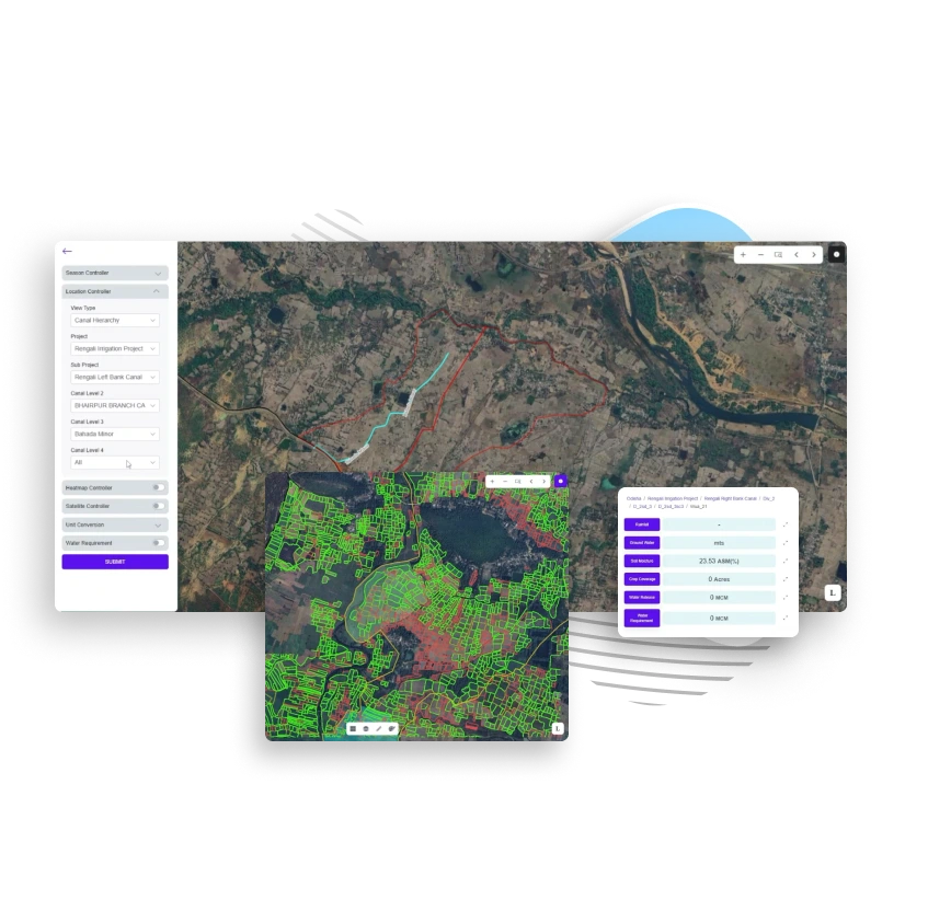
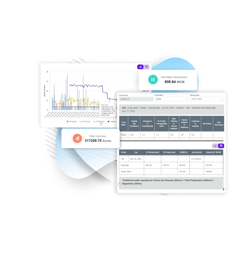
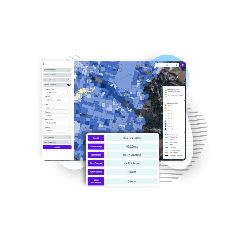
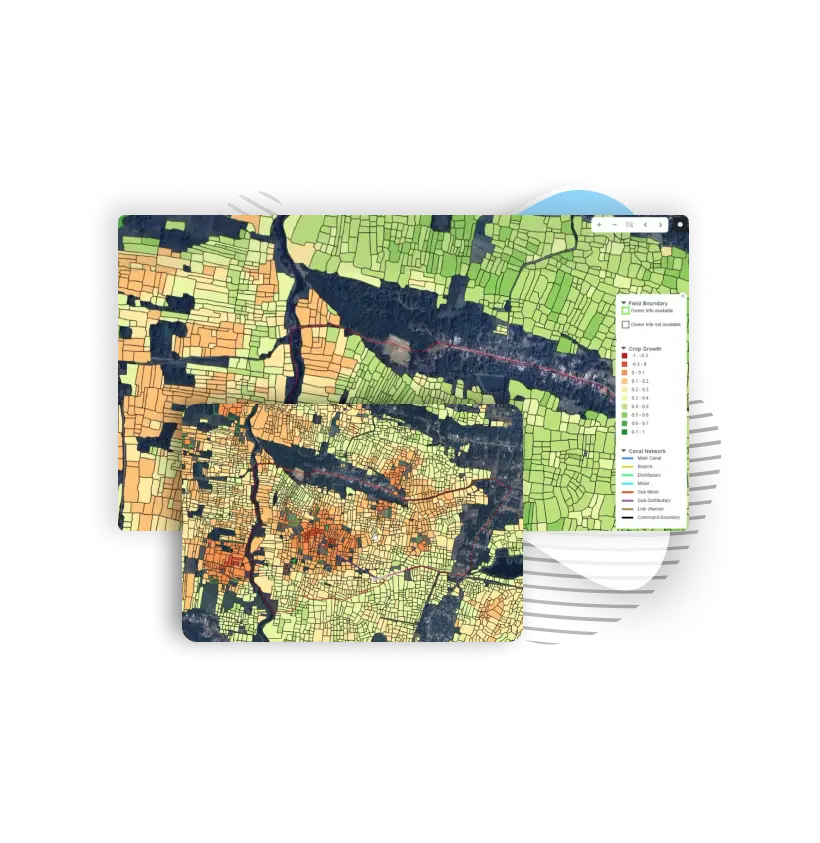
Enable efficient water allocation with aquaIRRIGATION, providing real-time IoT data, smart automation, and advanced crop models to optimize water use, boost yields, and reduce waste. Remotely manage systems, customize irrigation strategies, and access detailed reports for informed decisions

Plug and Play Modules Powered by aquaWISE

Ensure sustainable water management with advanced monitoring and analytics, enabling efficient resource utilization and compliance while minimizing wastage

Canal Network Optimization

Enhance water delivery with a dynamic weekly model that schedules irrigation releases based on crop water needs, canal capacities, and real-time data. Minimize water losses between canal sections for more efficient management.

Water Requirement Models

Accurately forecast crop water needs using real-time data and two-week projections. Guide reservoir releases to ensure efficient water distribution and mitigate shortages effectively.

Soil Moisture & Groundwater Insights

Receive daily updates on soil moisture levels, integrating soil conditions, crop needs, and weather data. Groundwater assessments further optimize overall water resource management for sustainable agriculture.

Satellite-Based Agriculture Monitoring

Utilize satellite technology to map cropping patterns, identify crops, and monitor health. Gain real-time insights into crop growth, irrigation, and stress levels, ensuring proactive field management.

Get Accurate Insights from Satellite Imagery, Machine learning predictive models and weather data to take right decisions at right time

Water Requirement Advisory

Get customized guidelines for water releases, factoring in demand, reservoir levels, and forecasted rainfall. Automated notifications keep irrigation officers informed and ensure timely action.

Decision Support Systems & Dashboards

Access interactive dashboards for water schedules, crop data, and stress maps. The Rainfall Dashboard offers detailed, drill-down rainfall data, enabling informed decision-making for water and crop management.

Water-Release Management Dashboard

Leverage advanced models to calculate water needs, monitor releases, and provide actionable advisories. With interactive MIS and GIS views, users can easily access detailed insights and optimize water management at every level.

Digital Twin of Canal Network

Creates a real-time replica of field conditions, visualizing crop types, health, and moisture using data from IoT sensors, mobile apps, SCADA systems, and satellite-based mapping.

Crop Sown Information

This module tracks crop distribution within the canal command area, recording crop type, sown area, and sowing date at various levels using satellite data and mobile apps.

Crop Water requirement computation

Receive precise, site-specific recommendations based on soil water balance modeling, climatic data, and crop parameters, helping irrigation managers allocate water efficiently, reduce waste, and improve resilience to climate variability.

In-Season Crop Type Identification

Transform crop identification with our satellite-based automated classification solution, using machine learning and time-series data for precise crop type detection, eliminating labor-intensive field surveys

Spatio-Temporal Crop Growth Assessment

Monitor crop health with high-resolution optical and microwave satellite data using our Vegetation Spectral Indices system. Track vegetation cover, biomass, and growth stages with real-time, cloud-corrected reports and interactive time-series

Surface Wetness Assessment

The system uses open-source satellite data to monitor surface wetness and irrigation patterns, combining microwave and optical technology for accurate, cloud-resistant moisture assessments.

Irrigation Extent Assessment

Optimize seasonal irrigation with our advanced system, using microwave and optical data for real-time coverage reports, water management, and efficiency summaries within the command area

Know More About aquaIRRIGATION

Maximize water use efficiency across canal systems, boost crop yields, and ensure sustainable irrigation along command areas.

Get In Touch