aquaFLOOD™
Stay ahead of extreme events
Forecast weather patterns and inflows at reservoir/basin levels along with inundation mapping. Further, get early alerts on incoming floods for optimal management
Forecast weather patterns and inflows at reservoir/basin levels along with inundation mapping. Further, get early alerts on incoming floods for optimal management
A comprehensive platform which uses real-time data from sensors, weather forecast, multiple other sources to generate flow forecasts and inundation resulting in early early warnings for risk mitigation
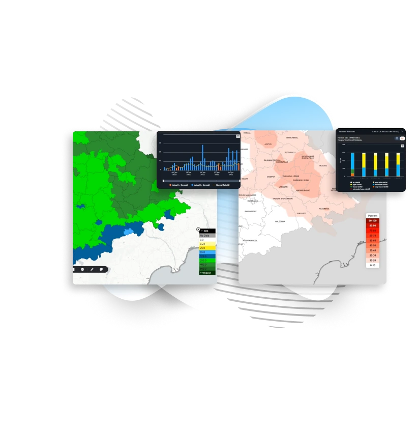
Weather forecasts from multiple sources are integrated and harmonised, including deterministic and ensemble approaches, thereby reducing uncertainty and enhancing decision-making in flood risk management
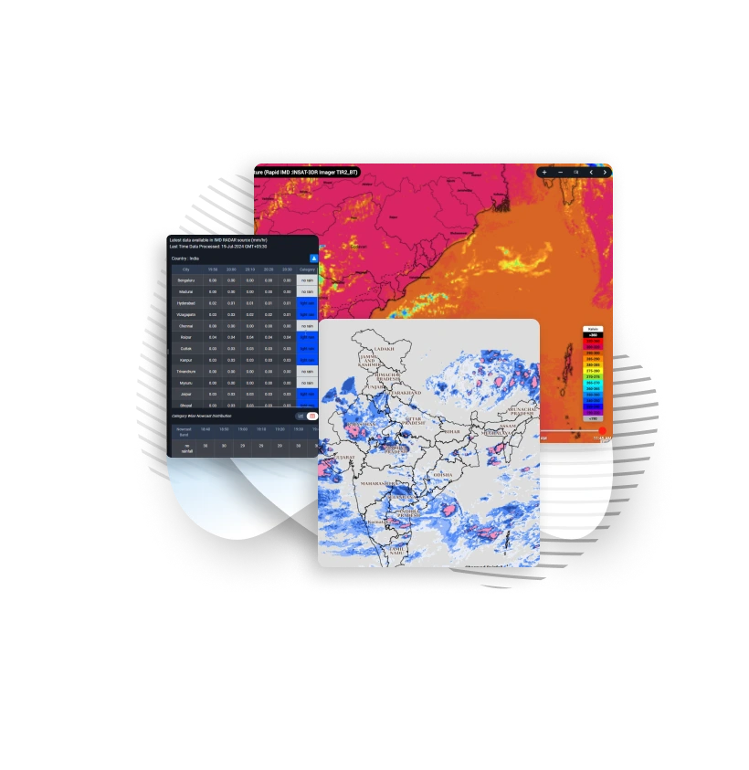
Get real-time data from weather radars, satellites, and ground observations to provide short term predictions, which is then fed into hydrological models to estimate immediate flood risks
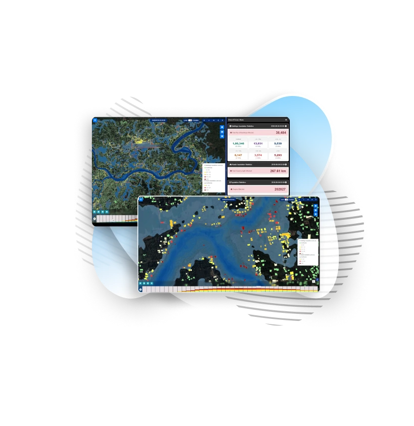
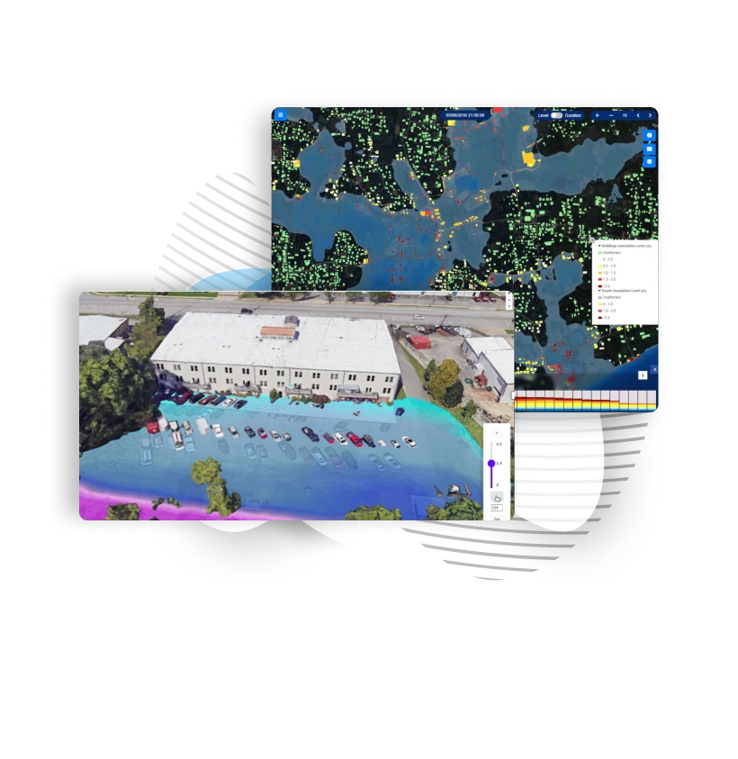
Simulate flood risk in 3D at rivers, dams, urban areas or at an individual property level. Detailed inundation map will cite insights on impacts and help in taking ahead of time preventive measures
Visualize flood risks in both 2D & 3D given flood-prone areas, allowing for a more precise understanding of potential water flow and inundation patterns
Get Accurate Insights from Satellite Imagery, Machine learning predictive models and weather data to take right decisions at right time
Integrate Hydrologic, Hydraulic and Stormwater models to provide a comprehensive analysis of flood risks by simulating rainfall-runoff process (hydrologic), movement of runoff through river channels and floodplains (Hydraulic) and management of stormwater in urban area
Predict the volume of water entering rivers, reservoirs, or flood-prone areas, helping to anticipate flood events. This data supports early warnings, reservoir management, and mitigation strategies to reduce flood risks
Insights on the extent and depth of floodwaters in specific areas which includes rivers, cities, individual property etc. helping to assess potential flood impacts. This will enable timely planning and preparedness for mitigating flood-related risks and damages.
The system enables forecasts that provide advance warning of the probable magnitude and timing of flooding, which is crucial for flood management.
Get analysis on varied return periods, events which will help to come up with inundation library. Simulate various flood as well as breach scenarios, also see inundation risk at critical zones
Evaluate structural integrity and effectiveness of levees in preventing floodwaters. 3D simulations to understand flood risk to further raise analysis on embankments designs to redirect floodwaters. Detect vulnerabilities to eliminate failures and ensure protection against flooding
Combine scientific data, models, and observations to understand the climate change patterns, their impacts on ecosystems and weather events
Alarms on flooding extent, risk advisories and impact assessments help in taking response action by concerned authorities for efficient disaster management.
Explore Climate technology solution with Vassar Labs – Pioneers in technology platform for efficient water management, precision agriculture, smart city services, energy and disaster